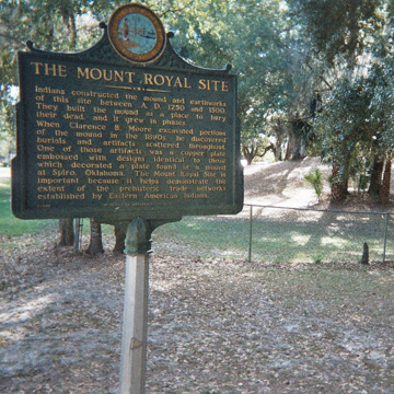
The Mount Royal archaeological site is located on the St. Johns River Offset in northeast Florida, an area adjacent to Lake George at resource-rich wetlands. A single mound and town complex, Mount Royal is enclosed within a private subdivision, though its one-acre site is owned by the state and publically accessible. It was added to the National Register of Historic Places in the 1970s.
Famously, John and William Bartram visited and catalogued the site in 1766, including drawings of the “Indian tumulus” and the surrounding village. Keith H. Ashley in Florida Anthropologist 58 (September–December 2005) notes that the elder Bartram (John) described the mound as “about 100 yards in diameter, nearly round, and nearly 20 feet high”; he also detailed one of Mount Royal’s most fascinating features, its central “avenue,” writing that "directly north from the tumulus is a fine straight avenue about 60 yards broad, all of the surface of which has been taken off and thrown on each side," thereby creating “banks” along its sides. William’s description, some fifteen years later, elaborated on this feature, describing a “noble Indian highway” that contributed to the “magnificence of the scene.” This artery “led from the great mount, on a straight line, three quarters of a mile,” and terminating finally “on the verge of an oblong artificial lake.”
C. B. Moore’s excavations in the 1890s revealed a wealth of archaeological objects, including burial remains, within the mound itself, as well as copper, stones, shells, and ceramics. His studies also reveal information about the formation of the earthwork, which was composed mostly of yellow sand but capped in a veneer of red-ochre sediment. Sand deposits were drawn from a “borrowed pit” located about 0.75 miles away. As described by the Bartrams, the mound was connected along a sunken thoroughfare to an artificial pond, and likely served as a burial place for important leaders. According to Jerald T. Milanch in his book The Timucua (1996), the causeway runs about 820 yards and varies in width from 12 to 25 feet. It was constructed by removing soil and piling it up along the sides, thereby creating ridge-lines running about 3 feet in height.
Archaeologists date the site to between 700 and 1050, during the St. Johns II period, and it was likely abandoned around 1300 CE. The St. Johns groups inhabited wetlands or forests in this northeastern corner of Florida, subsisting on fish and shellfish. Settlements from this culture, like Mount Royal, are notable for their sand mound construction, as opposed to shell formations. The Mount Royal complex was perhaps the major settlement complex within the Lake George area, whose chief, according to Milanich, achieved prodigious prosperity by around 1050 CE. The wealth of exotic objects uncovered here—such as copper artifacts—corroborates this claim, and further suggests that Mount Royal was an important regional trading center. Goods passing between the Gulf and Atlantic coasts found a way station at Mount Royal. When Europeans arrived in 1565, the site had been converted into the Timucuan village of Enacape, and in 1595 Spaniards established the San Antonio de Enacape mission. Today only the remains of the mission are extant, but the Mount Royal mound is open to the public. An informational kiosk at the mound’s base identifies the area.
References
Ashley, Keith H. "Archaeological Overview of Mt. Royal." Florida Anthropologist58, nos. 3–4. (September–December 2005): 265–86.
McDonald, Jerry N., and Susan L. Woodward. Indian Mounds of the Atlantic Coast. Newark, OH: The McDonald & Woodward Publishing Company, 1987.
Milanich, Jerald T. Famous Florida Sites: Crystal River and Mount Royal. Gainesville: University Press of Florida, 1999.
Milanich, Jerald T. Florida’s Indians from Ancient Times to the Present.Gainesville: University Press of Florida, 1998.
Milanich, Jerald T. The Timucua. Oxford: Blackwell Publishers, 1996.
Morgan, William N. Precolumbian Architecture in Eastern North America. Gainesville: University Press of Florida, 1999.

