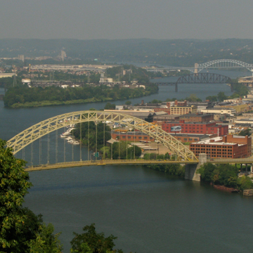
This and the McKees Rocks Bridge (1931, George S. Richardson, engineer; Ohio River Blvd., Termon Ave., and the Ohio River) went up as part of Allegheny County's energetic interwar program of improvements to its infrastructure, especially bridges and roads. The West End Bridge capitalizes on the 755-foot clear span of its steel parabolic arch to make an unforgettable impression as it bounds over the Ohio and simultaneously frames a view of Pittsburgh's Point. The McKees Rocks Bridge, a mere 2.5 miles northwest, unites five different units to achieve its length of nearly a mile over the “bottoms” of McKees Rocks and the Ohio. The engineering solution was to use a central through-arch of steel over the river itself, with vertical stays stiffening the deck and four severe stone pylons to give appropriate structural and visual support.
You are here
West End Bridge
If SAH Archipedia has been useful to you, please consider supporting it.
SAH Archipedia tells the story of the United States through its buildings, landscapes, and cities. This freely available resource empowers the public with authoritative knowledge that deepens their understanding and appreciation of the built environment. But the Society of Architectural Historians, which created SAH Archipedia with University of Virginia Press, needs your support to maintain the high-caliber research, writing, photography, cartography, editing, design, and programming that make SAH Archipedia a trusted online resource available to all who value the history of place, heritage tourism, and learning.


